The Roads That Remember
Under our Interstate at Night map, a commenter had a theory: older highways should have more communities around them. Cross-reference the exits with when the road was built, and a pattern should fall out. That one question sent us down a very deep rabbit hole, because the interstate system has a secret. Some interstates aren't really new roads at all.
When the system was laid out in 1956, engineers faced a choice on every corridor: pave alongside an existing US highway that had been collecting diners, motels, and main streets since the 1920s, or cut a brand-new alignment across open country. I-40 rides Route 66. I-95 rides US 1. I-81 follows US 11 so faithfully you can see the old road from the driver's seat for hundreds of miles. But other interstates were drawn on fresh paper, through land no numbered highway had ever crossed.
Seventy years later, our database can tell you exactly which choice they made. You just have to count what's at the exits.
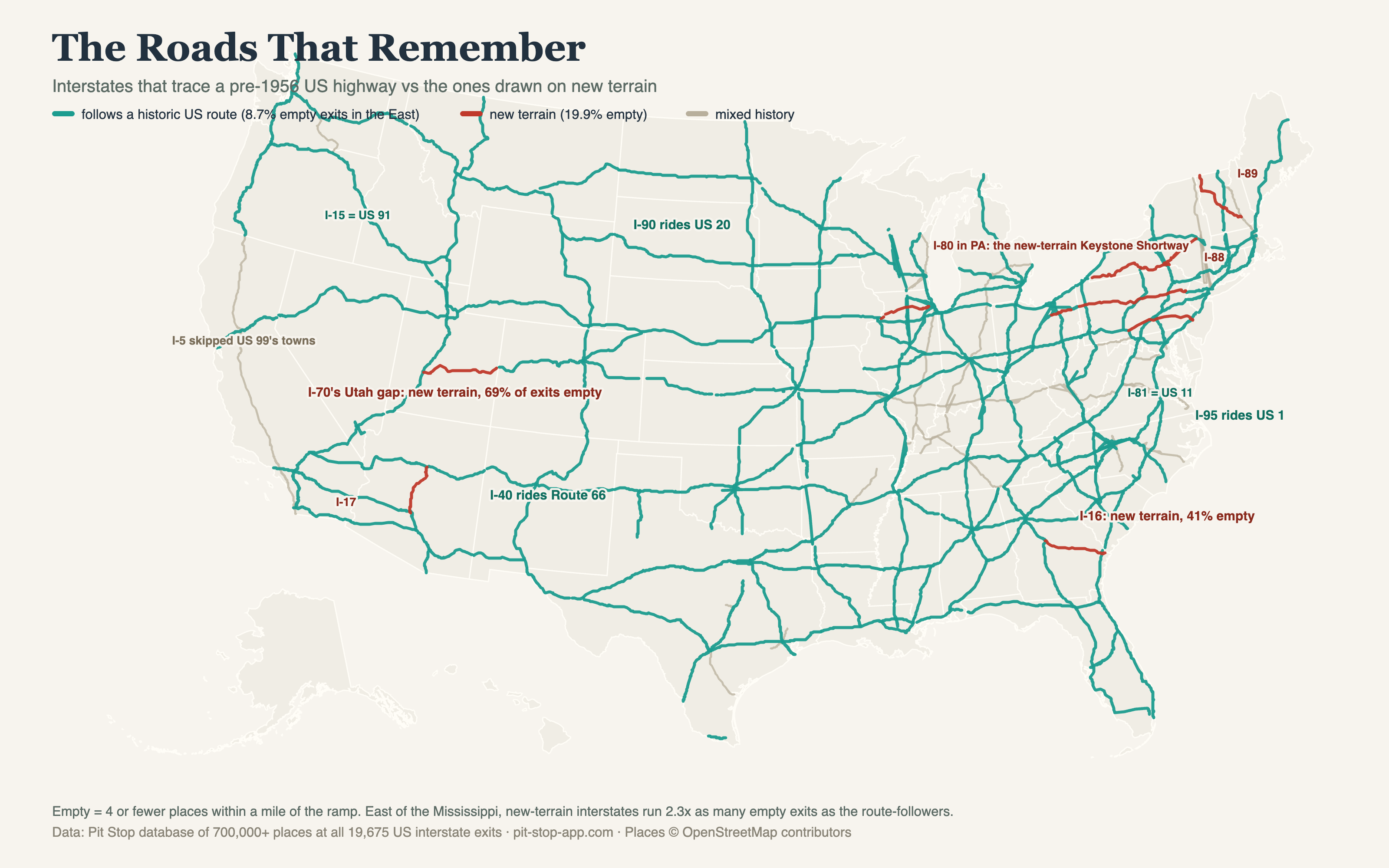
That's 456 empty exits out of 5,227 on the route-followers, against 44 of 221 on the new-terrain roads (I-16, I-88, I-86, I-89). Mixed-history corridors like I-70 and I-80 sit this comparison out.
Same road, different memory
The cleanest proof is I-70, because it's both kinds of road in one number. East of the Rockies it traces US 40, the old National Road, which has been carrying travelers since wagons. Across Ohio, 9% of its exits are empty. In Indiana it's 2%. Then in Utah, I-70 becomes something else entirely: roughly 105 miles across the San Rafael Swell where no US highway, no rail line, and basically no permanent settlement ever existed. The engineers called it the first interstate corridor built through completely new terrain. On that stretch, 69% of the exits are empty, and it holds the longest no-services run in America, the 100+ mile gap that shows up in our fuel desert and food desert posts. Same interstate number. The Ohio miles remember a century of travelers. The Utah miles have nothing to remember.
Hold the geography still and it gets stark
The skeptic's objection is geography: eastern corridors are full because the East is full. Fair. So compare roads in the same state.
| State | Follows an old US route | New terrain |
|---|---|---|
| Georgia | I-75 (US 41): 5% empty · I-85 (US 29): 1% | I-16: 41% empty |
| New York | I-90 (US 20): 0.8% empty · I-81 (US 11): 10% | I-88: 24% empty |
| Utah / Ohio | I-70 on US 40 in Ohio: 9% empty | I-70's new-terrain Utah run: 69% empty |
Georgia is the one that convinced us. I-16 and I-75 run through the same state, the same pine country, the same climate, the same economy. I-75 inherited US 41's roadside America: 152 exits, 95% of them stocked. I-16 was drawn through the space between the towns that US 80 had been serving since 1926, and today 41% of its exits are empty. Drivers call I-16 the most boring road in Georgia. The data says they're right, and it says why.
The counterexamples keep us honest
This isn't a law of physics. I-22 traces US 78 through the Alabama-Mississippi hill country and still runs 43% empty exits, and I-39, a straight upgrade of old US 51 through Illinois farm country, runs 47% empty there. A historic route through country that never had much keeps not having much. It cuts the other way too: I-89 was drawn on new terrain across Vermont and New Hampshire and only 7% of its exits are empty, because in New England you're never far from a town no matter what the road remembers.
And the biggest confound is real: the West is empty because the West is empty. I-15 follows US 91 the whole way and still runs 28% empty exits, because following a historic route across Nevada and Utah means following it through a lot of nothing. History decides where the towns are. Geography decides whether there are towns at all.
The one that bypassed on purpose
The strangest case is I-5 in California. Through the Central Valley, engineers deliberately did not follow US 99 and its string of farm towns, and built the Westside Freeway through empty ranchland instead. The towns kept their main streets; I-5 got 18% empty exits, the longest Sonic gap in America, and a service economy that had to be invented from scratch at places like Kettleman City, which exists almost entirely because two roads cross there. Meanwhile I-5 in Washington, where it does follow old US 99, runs 3% empty. One road, one number, both halves of the experiment.