1 in 8 Interstate Exits Has No Food At All
The great American road trip runs on a promise: there's always something at the next exit. We mapped every business at every interstate exit in the country for the Pit Stop app, and it turns out the promise has holes in it. Big ones.
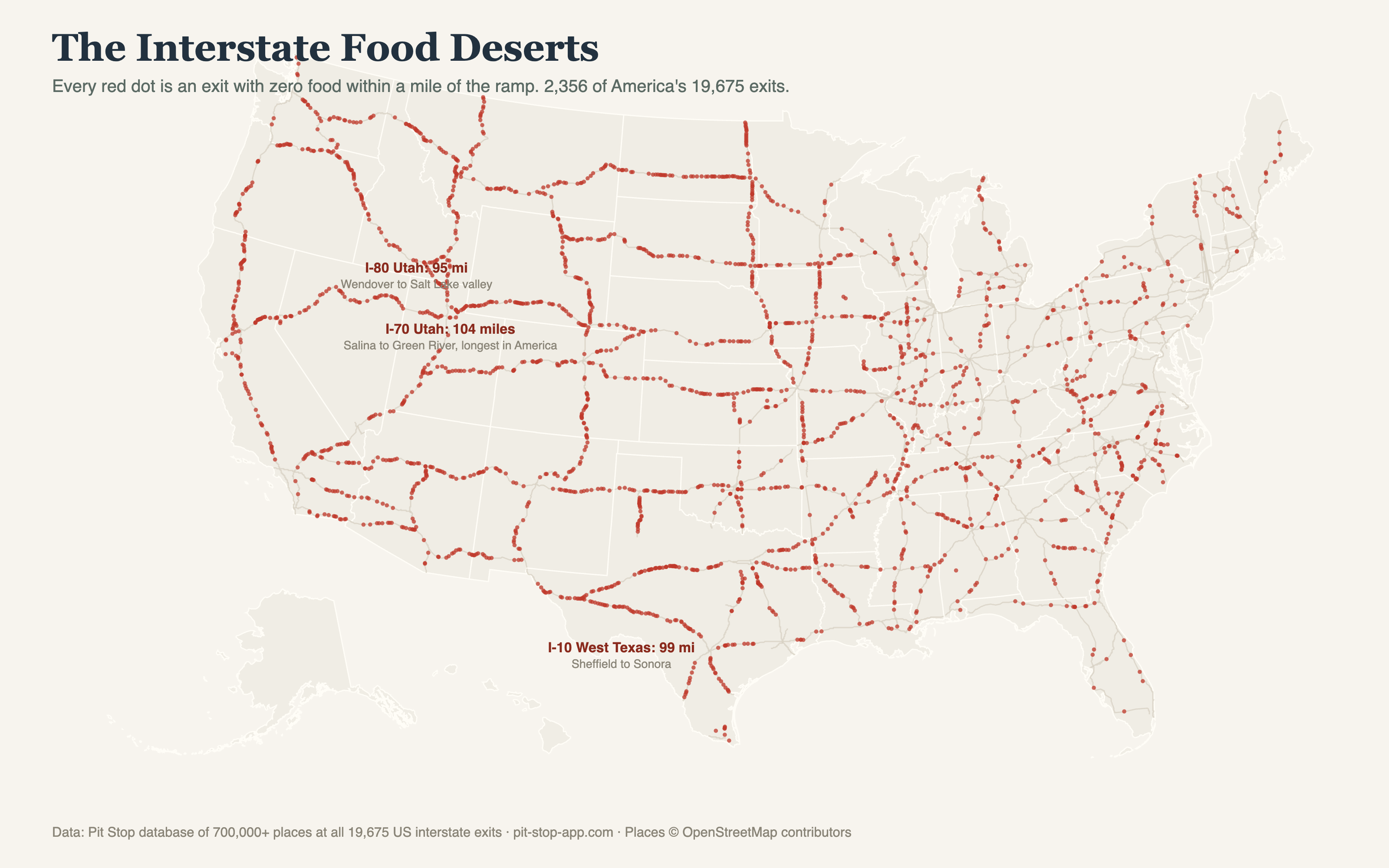
That's 12% of the system: one exit in eight where the ramp leads to a crossroads, a cattle guard, or a county road and nothing else. No drive-thru, no diner, no gas-station hot case.
The hungriest stretch in America
Food deserts cluster, and when they cluster on a long rural interstate you get the real records. The longest stretch in our data where an interstate offers no food at any exit:
| Stretch | Between | Miles without food |
|---|---|---|
| I-70, Utah | Salina to Green River | 104 |
| I-10, West Texas | roughly Sheffield to Sonora | 99 |
| I-80, Utah | Wendover to the Salt Lake valley | 95 |
The I-70 stretch through Utah's San Rafael Swell is the interstate system's most famous nothing: about 104 miles between meals by our count, and drivers who miss the warning signs at Salina find out the hard way. At 75 mph that's an hour and twenty minutes of watching an empty fuel needle and a hungrier back seat.
Where the food deserts live
The pattern is what you'd guess, but the scale isn't. The empty exits aren't just the Mountain West: they're the bypassed small towns of the Great Plains, the pine corridors of the Deep South, long runs of the northern border states. An "exit" in the interstate system is a legal off-ramp, not a promise of services, and 2,356 times out of 20,000 that distinction matters at dinnertime.
It's also why the exits that do have food matter so much to the towns around them. For thousands of small communities, the cluster at the ramp is the town's front door and its biggest source of passing trade. One exit either feeds you or it doesn't, and the difference is somebody's livelihood.
How to not get caught
The old answer is billboards and blue signs, which tell you about the next exit and nothing about the next hundred miles. The reason we built Pit Stop is exactly this gap: it shows what's at every exit ahead for the whole route, on your iPhone and on the CarPlay screen, so "should we stop now or push on?" becomes a decision instead of a gamble. On the I-70 stretch above, the app's answer is simple: stop in Salina. Trust us.