The Trucker's Map of America
Under our interstate history map, a long-haul trucker left a comment that stopped us cold: "We make it illegal for them to keep driving, and we make it illegal for them to stop." Federal hours-of-service rules shut a driver down when the clock runs out, wherever they happen to be. And then whole stretches of the country offer nowhere legal to put 70 feet of truck. A hundred and fifty people upvoted it, because every driver knows.
We have every place at every interstate exit, so we mapped what a driver actually has to work with: every major chain truck stop (Pilot, Flying J, Love's, TA, Petro, Sapp Bros, Road Ranger) and every public rest area on the interstate system.
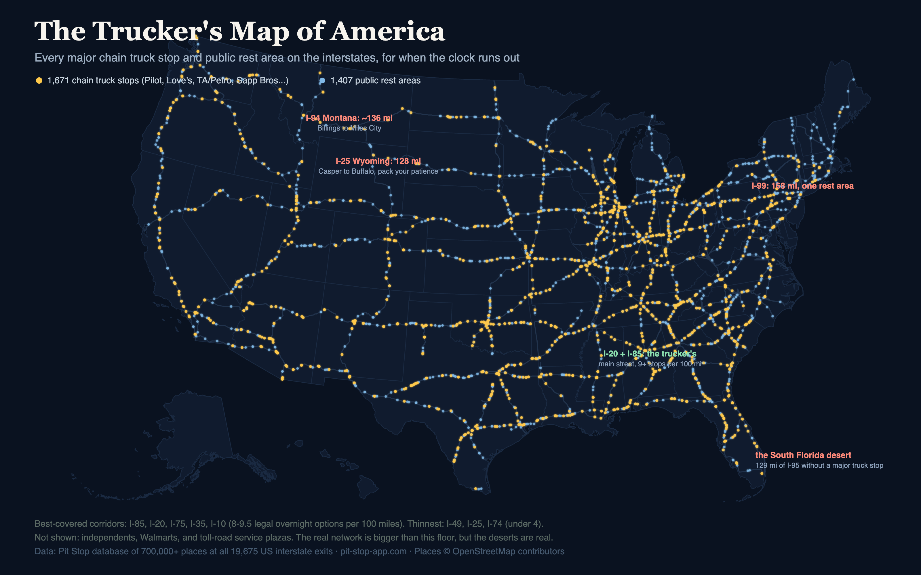
And the longest desert on I-95 isn't in the middle of nowhere. It's Miami.
The best roads to run out of clock on
| Corridor | Overnight options / 100 mi | What's there |
|---|---|---|
| I-85 | 9.5 | 43 chain stops + 27 rest areas on 655 mi |
| I-20 | 9.1 | 101 chain stops + 65 rest areas on 1,527 mi |
| I-75 | 8.7 | 96 + 78 on 1,739 mi |
| I-35 | 8.2 | 80 + 62 on 1,410 mi |
| I-10 | 8.1 | 142 + 96 on 2,418 mi |
The pattern is the southern freight economy: I-20 and I-85 through the Southeast, I-35 and I-10 across Texas. Roughly every 11 miles, something with diesel and a parking lot. At the other end: I-49 (3.3 per 100 miles), I-25 (3.8), and I-74 (3.9), the newer and emptier corridors where the clock is genuinely scary.
The parking deserts
| Stretch | The gap |
|---|---|
| I-99, Pennsylvania | 168 miles with a single rest area and no major chain truck stop on the route |
| I-94, Montana | ~136 miles, Billings to Miles City |
| I-95, South Florida | 129 miles north from Miami without a major truck stop |
| I-25, Wyoming | 128 miles, Casper to Buffalo |
| I-15, Montana | 118 miles through the middle of the state |
The South Florida one is the tell. Rural deserts happen because there's no traffic to serve. Urban deserts happen because land that could park forty trucks makes more money as anything else, and every ramp for a hundred miles says NO TRUCK PARKING. The densest freight destinations in America are the hardest places to legally sleep next to. Truckers have been saying this for years; the map just agrees with them.
What the trucker actually asked for
The commenter who started this made a sharper point than any statistic: most nights a driver doesn't want the giant famous travel center. They want the nearest legal spot to where the clock dies, something they can get into fast and out of fast at 5am. The mega-stops are for the 34-hour reset. That's a routing problem, not an amenities problem, and it's exactly the kind of thing our data is shaped for. We're working on a parking-first view in the Pit Stop app: rest areas, truck stops, and 24-hour exits, sorted by distance ahead of you.
The honest fine print
This map is a floor, not a ceiling. It shows major chains and public rest areas because those are reliably mapped. It does not show independent truck stops, Walmarts and casinos that tolerate overnighting, or toll-road service plazas (so the turnpikes look emptier here than they are). It also can't see NO PARKING signs, which truckers tell us make real life worse than any map. Rest-area data quality varies by state. Corrections from drivers welcome and wanted: jake@pit-stop-app.com.