The Inheritance Ladder
Yesterday we published The Roads That Remember: interstates that traced a pre-1956 US highway have full exits, and the ones drawn on fresh ground run empty. Within six hours, four different commenters on reddit, in two different subreddits, poked the exact same hole in it, each armed with a different road.
New York's I-86 follows old NY 17, one said, so why is it colored "new terrain"? Illinois' I-88 follows IL 2, said another. Wisconsin's I-43 rides old WI 15 south of Milwaukee. Arizona's I-17 sits on the old Black Canyon Highway, state routes 69 and 79. Four strangers, four states, one seam: what about the interstates that followed a road that wasn't a US route, but a state route?
So we split the data three ways instead of two. They found something.
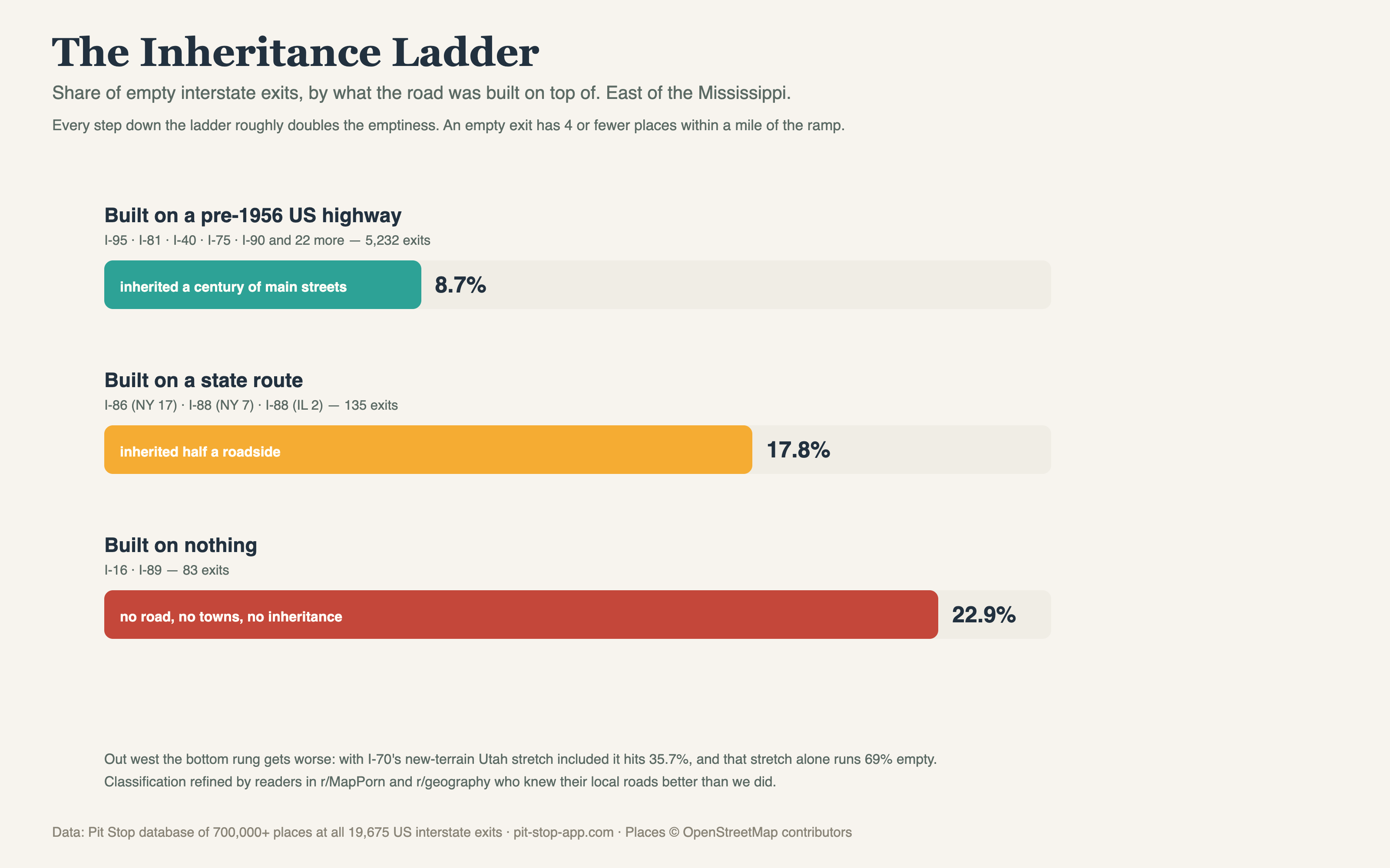
East of the Mississippi, holding geography roughly constant. An empty exit has 4 or fewer places within a mile of the ramp.
Why the middle rung exists
A US numbered highway wasn't just pavement. From 1926 on, it was a national brand: the routing that maps sold, tourism followed, and roadside economies were built around. Diners, motor courts, gas stations, whole main streets aligned themselves to US 40 and US 66 and US 11 for thirty years before the interstates arrived. When an interstate landed on one of those corridors, it inherited all of it.
A state route carried real traffic but rarely that gravity. Old NY 17 was a genuine artery to the Southern Tier; the villages were there. But the roadside economy strung along a state route was thinner, and when the freeway came through it usually came through beside the old road rather than on top of it. The exits inherited half a roadside. The data says that half shows: 17.8% empty, right between the two worlds, and remarkably consistent across its members: I-86 New York 18%, I-88 Illinois 21%, I-88 New York 24%.
The best part: Arizona's I-17, which we didn't use to build the tier, lands at 18%, matching its eastern siblings almost exactly from two thousand miles away. When an out-of-sample road falls right on the line, the line is probably real.
The fine print, honestly
These are small groups: 135 exits on the state-route rung and 83 on the bottom one, against 5,232 on the US-route rung, so the exact percentages should be held loosely. New England blurs the bottom rung: I-89 was cut across Vermont on fresh ground and still runs under 10% empty, because in New England you're never far from a town. And out west the ladder stretches: adding I-70's new-terrain Utah stretch takes the bottom rung to 35.7%, with that stretch alone at 69%.
One more correction from the same threads, gladly taken: I-43 in Wisconsin belongs on multiple rungs at once. Its north half follows old US 141, its south half old WI 15, and its lakeshore leg was new construction, which is why it sits in the mixed pile rather than any tier.